The early twentieth century witnessed significant advancements in shipping technology, which directly impacted the infrastructure of port cities worldwide. The expansion of Mumbai’s ports between 1914 to 1947 A.D. stands as a critical phase in the evolution of maritime trade in the region. As shipping vessels grew in size, driven by the increasing demand for cargo capacity, port facilities had to adapt to accommodate these larger vessels. This necessitated deeper draughts, thus leading to a significant transformation of Mumbai’s maritime landscape. This article examines the first phase of port expansion in Mumbai, focusing on the construction of new docks and the environmental and geomorphological consequences of these developments.
TECHNOLOGICAL ADVANCES IN MARITIME ACTIVITIES:
The period between 1914 to 1947 marked a pivotal era in the history of maritime activities. The transition from traditional sailing vessels to steam-powered ships revolutionized the shipping industry, increasing the efficiency and capacity of maritime trade. New technologies in ship-building allowed for larger vessels capable of carrying greater loads, which in turn demanded more sophisticated port infrastructure. These technological advancements placed increasing pressure on existing ports to upgrade their facilities, particularly in terms of draught depth. Draught depth, referring to the vertical distance between the waterline and the lowest point of a ship’s hull, became a critical factor in determining the size and capacity of a port. Ports that could accommodate deeper draughts were crucial for the continued expansion of maritime trade.
PORT EXPANSION AND THE CONSTRUCTION ON NEW DOCKS:
In response to the increasing size of vessels and the corresponding need for deeper draughts, Mumbai’s port facilities underwent significant expansion. The first phase of this expansion saw the construction of additional dry docks, notably Hughes Dry Dock, Alexandra Dock, and Mazagaon Dock. These new structures were designed to accommodate larger ships and improve the operational efficiency of the port.
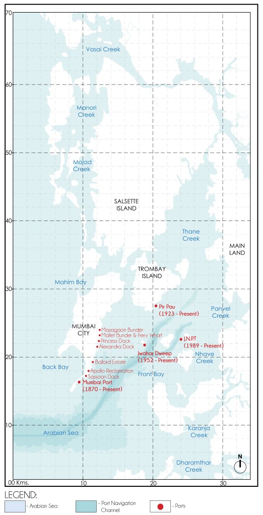
The Alexandra Dock, in particular, was a major milestone in the port’s development. Completed in the early 20th century, the Alexandra Dock was constructed to a draught depth of 10.7 meters, making it the most modern and advanced dock in Mumbai at the time. This increased draught depth was achieved by extending the dock further into the sea, allowing it to accommodate larger vessels that could no longer navigate the shallower parts of the harbor. The expansion of the Alexandra Dock marked a significant engineering achievement, reflecting the growing importance of Mumbai as a hub for international trade.
ENVIRONMENTAL AND GEOMORPHOLOGICAL IMPLICATIONS:
While the port expansion brought significant economic benefits to Mumbai, it also had unintended environmental consequences. The process of extending docks into deeper waters and constructing sea walls and embankments disrupted the naturally occurring geomorphological processes of the region. In particular, the natural flow of tidal currents, which previously played a crucial role in sediment transport and coastal erosion, was significantly altered by these human interventions.
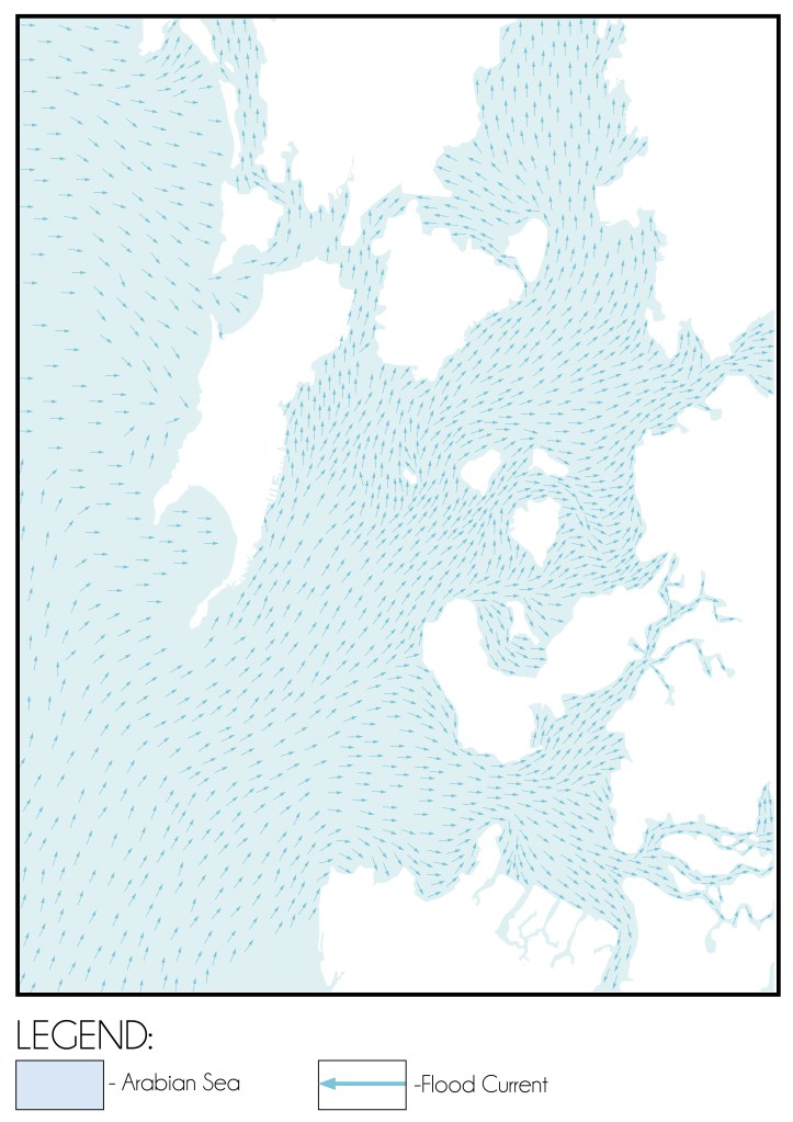
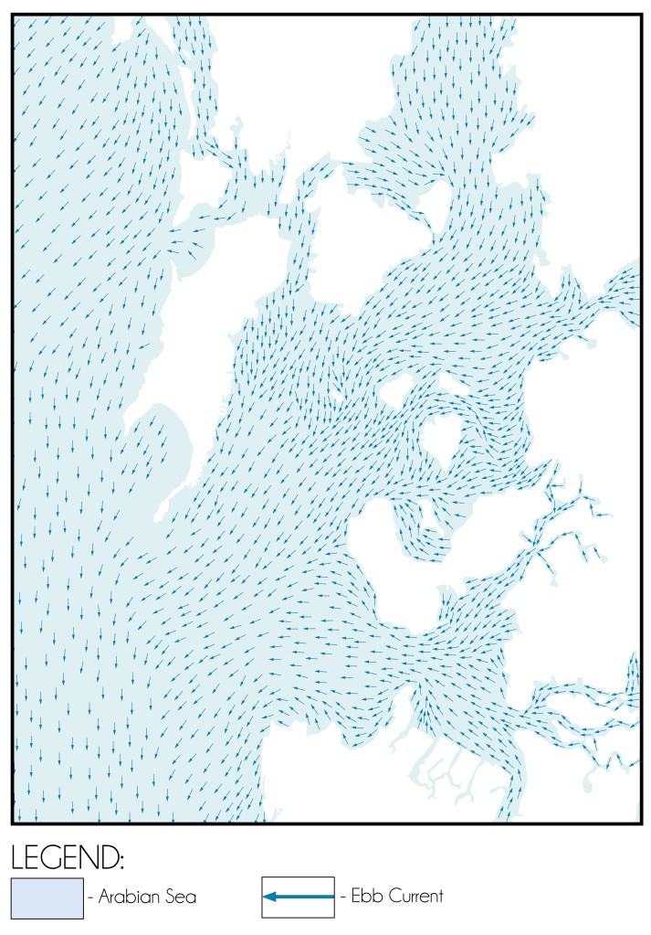
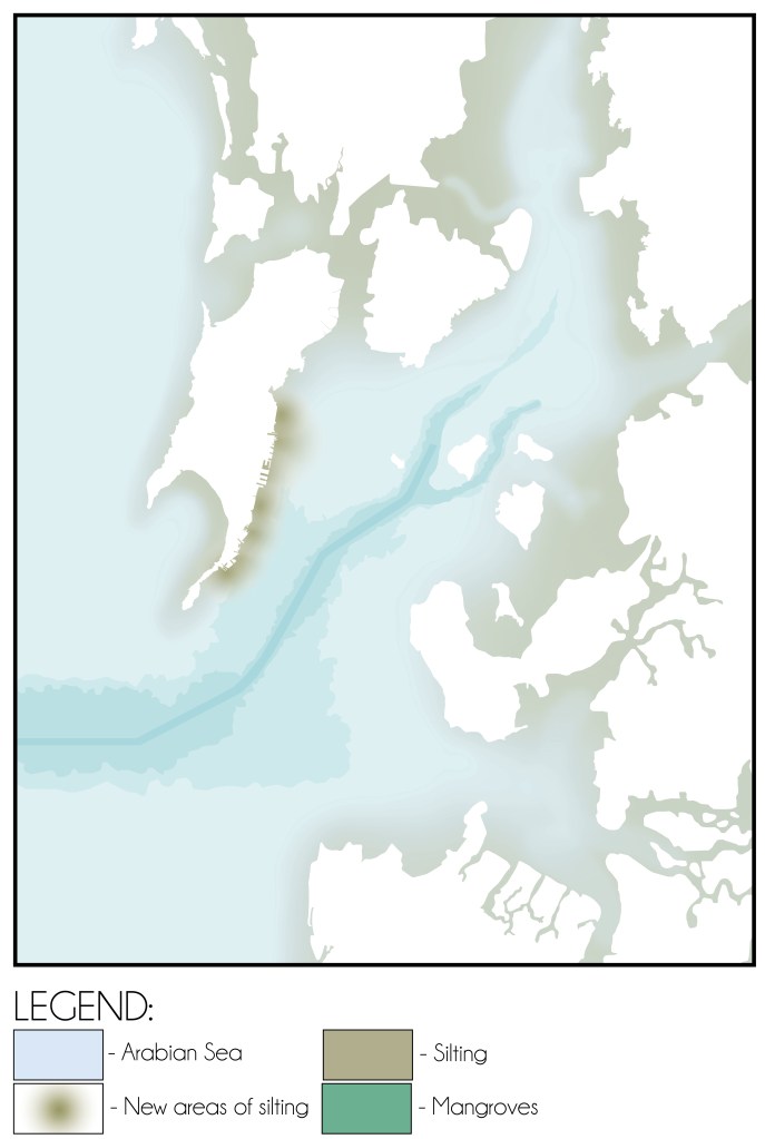
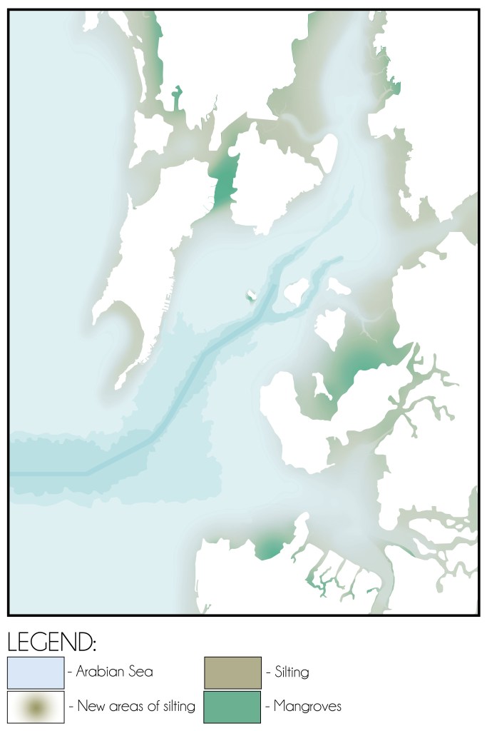
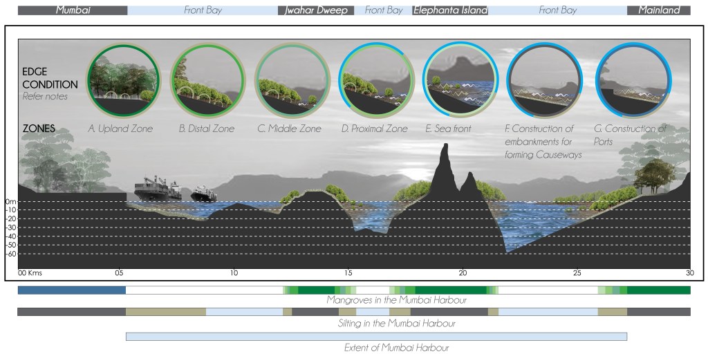
The construction of sea walls and embankments, while essential for protecting the expanded port infrastructure, inadvertently caused a shift in the movement of sediment. Silt, which was previously transported away from the harbour by natural currents, began to accumulate in the Main Navigation Channel — the deepest part of the Mumbai Harbour as indicated in Fig. 04. This sedimentation posed a growing challenge for port operations, as the accumulation of silt in the navigation channels threatened to obstruct the passage of large vessels. The disruption of natural processes, combined with the increased sedimentation, created a long-term challenge for port management, requiring constant dredging to maintain navigability.
CONCLUSION:
The first phase of port expansion in Mumbai, spanning from 1914 to 1947, marked a significant chapter in the city’s maritime history. The development of new docks, particularly the Alexandra Dock, was a response to the growing demands of modern shipping technology. However, this expansion came with environmental and geomorphological challenges that continue to affect the port today. The disruption of natural processes, including the accumulation of silt in the Main Navigation Channel, highlights the complex interplay between human intervention and the environment. As the port continued to grow in the years that followed, these challenges would require increasingly sophisticated engineering solutions to ensure the continued success of Mumbai’s maritime trade.
Bibliography:
- Input reduction and acceleration techniques in a morphodynamic modeling: A case study of Mumbai harbor; Author: Balaji Ramakrishnan, Niraj Pratap Singh, Satheeshkumar Jeyaraj
- Cover photo courtesy: https://parsi-times.com/2024/07/eminence-and-ascendancy-of-parsis-in-early-india-ii/
References:
- The Rise of Bombay: A Retrospect; Author: S. M. Edwardes Publisher: Times of India Press, Mumbai, 1902
- A Study on the Eastern Waterfront of Mumbai: A Situation Analysis conducted between August 2000 – December 2001; Author: Design Cell: Kamla Raheja Vidyanidhi Institute of Architecture and Urban Design Research Institute. Publisher: Urban Design Research Institute, Mumbai, 2001.
- Tides of Time: A History of Mumbai Port; Author: V. M. Kamath Publisher: Mumbai Port Trust, Mumbai.
Author’s Note:
If this topic interests you, explore the category titled the ‘The Dissolution of Mumbai Harbour’ . The published articles under this category include:
- The Dissolution of Mumbai Harbour: An Introduction
- The Dissolution of Mumbai Harbour: A Conducive Setting
- The Dissolution of Mumbai Harbour: Influence of Anthropogenic Activities c. 1650-1668 A.D.
- The Dissolution of Mumbai Harbour: Influence of Anthropogenic Activities c.1668 to 1873 A.D.
- The Dissolution of Mumbai Harbour: Influence of Anthropogenic Activities c. 1873 to 1914 A.D.
- The Dissolution of Mumbai Harbour: Influence of Anthropogenic Activities c. 1914 to 1947 A.D.

Leave a comment