The historical evolution of Mumbai Harbour reflects a dynamic interplay between natural processes and anthropogenic interventions. Following the period of causeway construction and fortification (1668–1873), the subsequent phase between 1873 to 1914 witnessed an accelerated transformation driven by global economic shifts. The opening of the Suez Canal in 1869 drastically reconfigured maritime trade patterns, emphasizing Mumbai’s strategic location and necessitating the construction of modern port infrastructure. This study analyses the methods employed in port construction during this era and investigates their subsequent impact on the natural coastal system.
STRATEGIC IMPORTANCE & INFRASTRUCTURE DEVELOPMENT:
The inauguration of Suez Canal offered a shortened maritime link between Europe and Asia, catalyzing Mumbai’s emergence as a principal gateway for British India. To accommodate increasing trade volumes, a series of docks were developed:
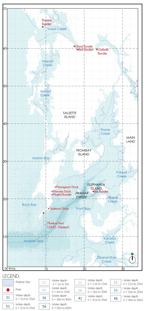
Sassoon Dock (1875 A.D.) is one of the oldest docks in the city of Mumbai. It is the first commercial wet dock and its operations include handling of fisheries.
Prince’s Dock (1885 A.D.) was built as part of the scheme to improve the foreshore of Bombay Harbour.
Victoria Dock (1888 A.D.), another wet dock built with the intention to transform Mumbai into a major shipping and trade hub.
These docks represented a significant shift from traditional, small-scale landing facilities to large, organized maritime infrastructures designed for industrial-scale trade operations.
METHODS OF PORT CONSTRUCTION:
The construction process involved two principal engineering strategies:
Erection of Retaining Walls: Robust retaining structures were built along the shoreline to secure the reclaimed land against the forces of erosion and tidal action. These walls served a dual function: they stabilized the newly formed edges of the harbour and provided a durable boundary between land and sea.
Land Reclamation: To accommodate the increasing size and draught of modern vessels, significant areas of the sea were infilled. This process elevated the seabed to create stable platforms while also shaping deep water basins suitable for port operations. Specifically, reclamation efforts ensured that Prince’s Dock maintained a draught of 6.4 meters, while Victoria Dock achieved 7.3 meters, allowing for the safe mooring, loading, and unloading of large commercial ships.
As indicated in Fig.01 the main port navigation channel was defined in alignment with the naturally deepest sections of the harbour.
GEOMORPHOLOGICAL IMPACTS
The construction activities led to a dramatic alteration of the natural coastal morphology:
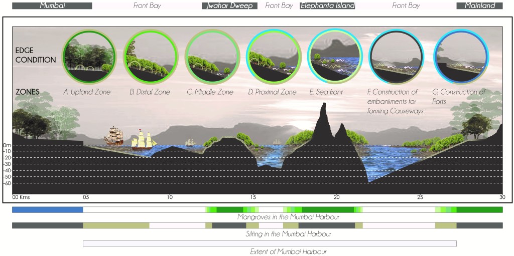
Loss of Gradual Coastal Transition:
One of the most profound impacts of the construction activities was the transformation of the coastline’s natural morphology. Historically, the shoreline featured a gentle, sloping transition from terrestrial to marine environments—an ecologically rich interface that supported tidal wetlands, mangroves, intertidal flats, and other dynamic coastal systems. This gradual gradient played a crucial role in dissipating wave energy, facilitating sediment transport, and sustaining biodiversity.
However, the introduction of vertical or near-vertical engineered sea walls replaced this natural slope with rigid, man-made boundaries. These abrupt transitions sharply curtailed the ecological connectivity between land and sea. Such engineered edges offer limited habitat complexity and fail to support the natural processes of accretion, erosion, and tidal exchange. Moreover, they intensify the reflective energy of waves, often leading to scouring of the seabed at the base of the walls and necessitating ongoing maintenance or further reinforcement.
In essence, while the sea walls were vital for land stabilization and maritime infrastructure, they fundamentally altered the coastal character, converting a biologically active and morphologically fluid zone into a static and ecologically impoverished boundary.
Destruction of Mangrove Ecosystems:
The construction activities led to the widespread clearance of mangrove forests that once fringed the natural shoreline. These ecosystems served as vital buffers between land and sea, playing a critical role in coastal stability. The complex root systems of mangrove trees effectively trapped sediments carried by tides, promoting land formation and reducing shoreline erosion. By anchoring the soil, mangroves also helped to prevent sediment resuspension. This shift from nature-based to artificial coastal defense systems marked a permanent alteration of the coastal ecosystem.
Disruption of Sediment Dynamics:
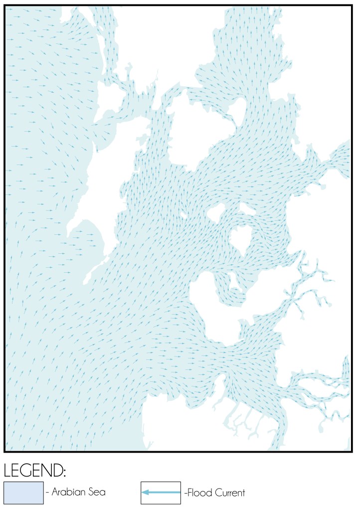
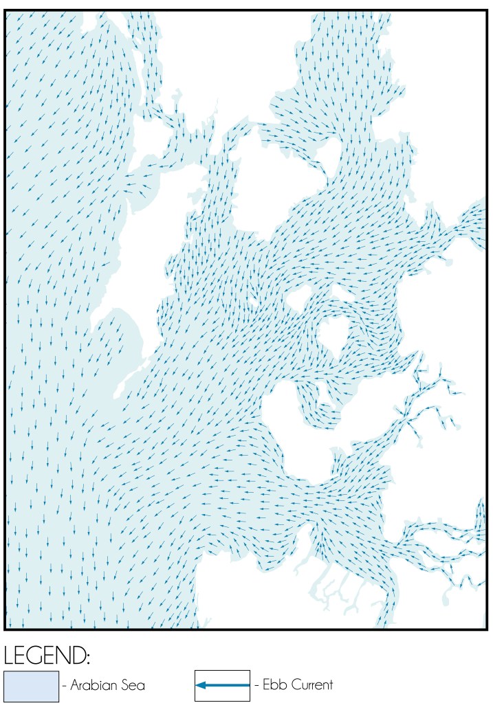
Fig. 02 and Fig. 03 indicate the flood current and ebb current dynamics in the Mumbai Harbour. Previously, silt carried by flood currents would settle along the gradual slopes, arrested by vegetation. Following the construction, sediment was no longer trapped along the shoreline but began migrated into the deeper harbour regions.
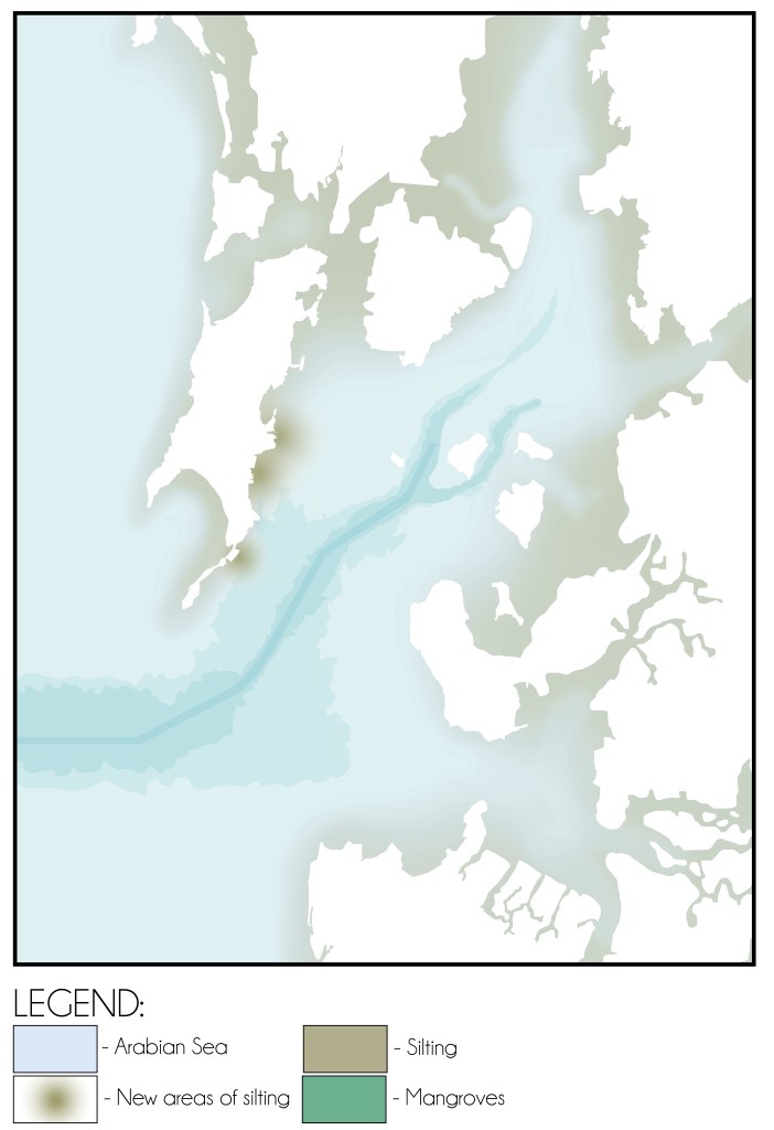
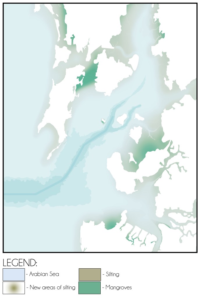
These changes began causing siltation within the port navigation channel, directly threatening navigability and necessitating regular dredging operations—a burden created by the very infrastructural interventions intended to promote maritime trade.
CONCLUSION:
The period from 1873 to 1914 marks a defining chapter in the anthropogenic transformation of Mumbai Harbour. Driven by global maritime realignments, the construction of major port infrastructure altered both the physical and ecological character of the region.
While the construction of ports significantly enhanced Mumbai’s economic stature, it also initiated a cascade of environmental consequences. The engineered coastline disrupted the delicate balance of natural sediment transport processes, resulting in siltation of the harbour.
These siltation problems underscore the complexities inherent in large-scale coastal engineering projects, highlighting the need for a more integrated approach that accounts for both developmental and environmental imperatives. Understanding this historical trajectory is crucial for informing future coastal and harbour management strategies.
Bibliography:
- Input reduction and acceleration techniques in a morphodynamic modeling: A case study of Mumbai harbor; Author: Balaji Ramakrishnan, Niraj Pratap Singh, Satheeshkumar Jeyaraj
References:
- The Rise of Bombay: A Retrospect; Author: S. M. Edwardes Publisher: Times of India Press, Mumbai, 1902
- A Study on the Eastern Waterfront of Mumbai: A Situation Analysis conducted between August 2000 – December 2001; Author: Design Cell: Kamla Raheja Vidyanidhi Institute of Architecture and Urban Design Research Institute. Publisher: Urban Design Research Institute, Mumbai, 2001.
- Tides of Time: A History of Mumbai Port; Author: V. M. Kamath Publisher: Mumbai Port Trust, Mumbai.
Author’s Note:
If this topic interests you, explore the category titled the ‘The Dissolution of Mumbai Harbour‘ . The published articles under this category include:
- The Dissolution of Mumbai Harbour: An Introduction
- The Dissolution of Mumbai Harbour: A Conducive Setting
- The Dissolution of Mumbai Harbour: Influence of Anthropogenic Activities c. 1650-1668 A.D.
- The Dissolution of Mumbai Harbour: Influence of Anthropogenic Activities c.1668 to 1873 A.D.
- The Dissolution of Mumbai Harbour: Influence of Anthropogenic Activities c. 1873 to 1914 A.D.
- The Dissolution of Mumbai Harbour: Influence of Anthropogenic Activities c. 1914 to 1947 A.D.

Leave a comment