Around c.1750 the archipelago of Mumbai was ceded to the British. The British were aware of the importance of Mumbai for direct communication with Persia, Malabar Coast and Maluku Islands but they also realised the difficulty in governing separate islands and threat to life while navigating through sea to access all the islands.
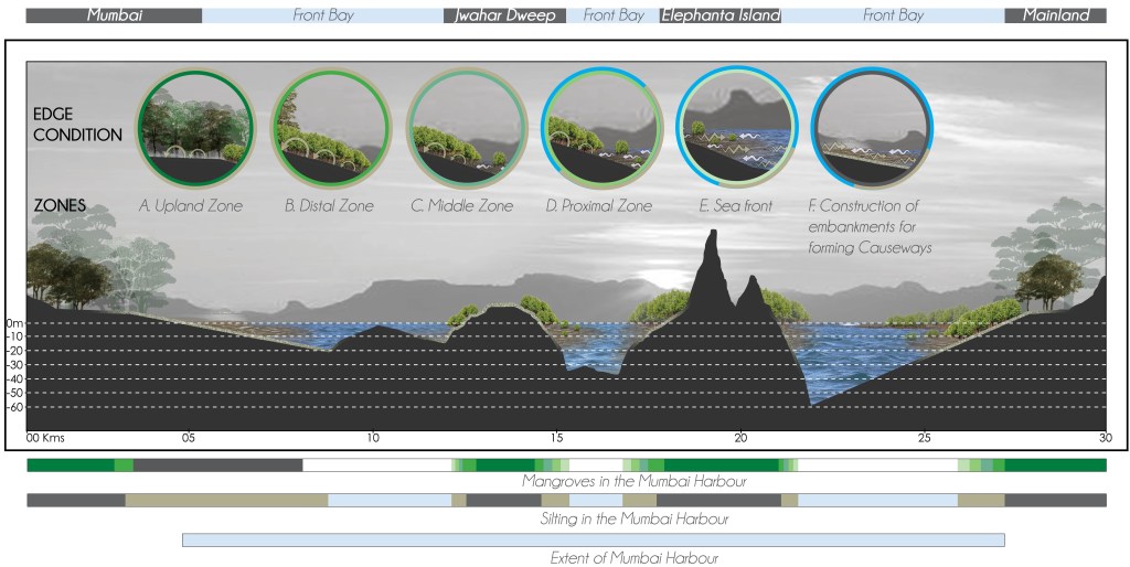
To ensure administrative convenience the British built embankments and constructed causeways with the intention of creating one landmass as illustrated in Fig. 01.
Among the key projects that unified the islands of Bombay were the Hornby Vellard, the Colaba Causeway, and the Mahim Causeway.
THE CREATION OF AN ENGINEERING MARVEL THAT LED TO THE DEMOLITION OF AN ECOLOGICAL NETWORK:
The British-led construction of embankments and causeways was not merely a matter of infrastructural advancement instead it represented a significant intervention in the region’s hydrological dynamics. These projects, often driven by the desire to increase arable land, facilitate transportation, or impose territorial control, fundamentally reconfigured the natural relationship between land and water. While these efforts succeeded in creating a continuous landmass more suitable for colonial administrative and economic needs, they came at a steep ecological cost.
The region’s tidal network, a system that had developed over centuries through the interplay of riverine and marine forces was a living, adaptive infrastructure in its own right. It regulated flooding, supported biodiversity, replenished fertile soils, and underpinned local modes of agriculture and settlement. The embankments and causeways, by severing the land from these tidal rhythms, dismantled this self-sustaining system. Water that once ebbed and flowed naturally was trapped or diverted, leading to increased sedimentation in some areas, and erosion and salinization in others. This anthropogenic activity, involving construction of embankments and causeways did not affect the oceanography of the Mumbai Harbour but seriously altered, rather destroyed the tidal exchange between the Front Bay and the Back Bay.
Thus, what was framed as progress, was in reality, a profound disruption: a reordering of natural systems to serve immediate colonial objectives, with long-term consequences that continue to shape the region’s ecology and society.
SILTATION AND ITS EFFECTS ON COASTAL MORPHOLOGY:
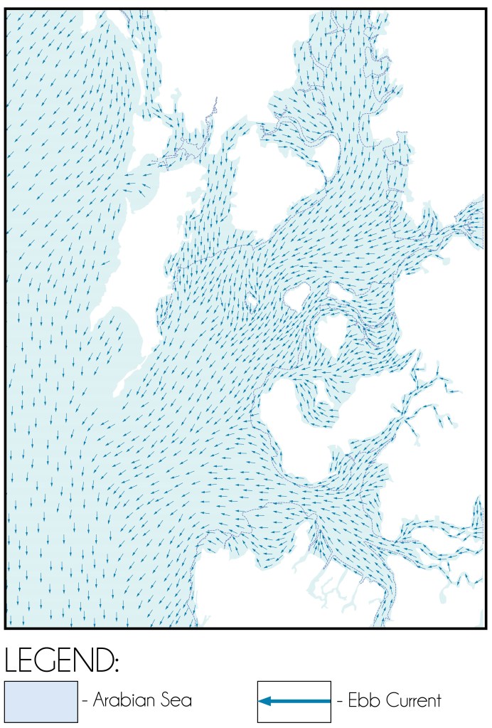
Although the oceanography of the Mumbai Harbour remained largely unaffected, the alterations severely impeded tidal exchange between the Front Bay and the Back Bay. The once-permeable inter-island channels that facilitated the movement of flood and ebb currents between the Front Bay and Back Bay were now blocked, leading geomorphological changes.
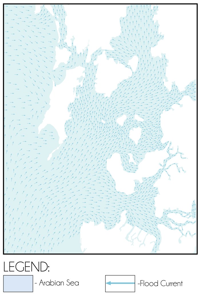
As demonstrated in Fig. 04, the newly constructed barriers restricted the flow of silt-laden tidal waters into the areas between the islands during high tide. Consequently, large volumes of sediment brought in by the flood currents became trapped within the confines of Mumbai Harbour. This interruption of tidal exchange triggered two key geomorphological shifts:
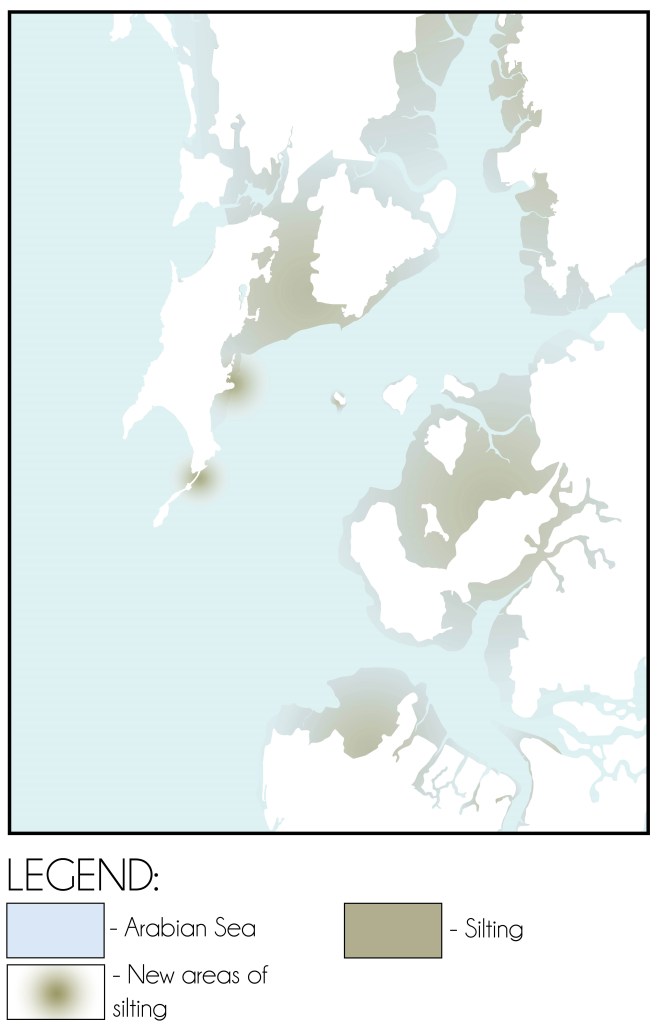
DISPLACEMENT OF SILT DEPOSITION:
As indicated in Fig. 06, silt that would have otherwise dispersed evenly across the intertidal zones between the islands began accumulating along the coastline facing the open sea. This shift disrupted the natural sediment transport processes that had maintained a dynamic equilibrium between land and water for centuries. In the absence of regular tidal flushing, fine sediments settled more rapidly, promoting the unchecked expansion of mudflats, swamps, and marshes in areas that had previously experienced balanced tidal action.
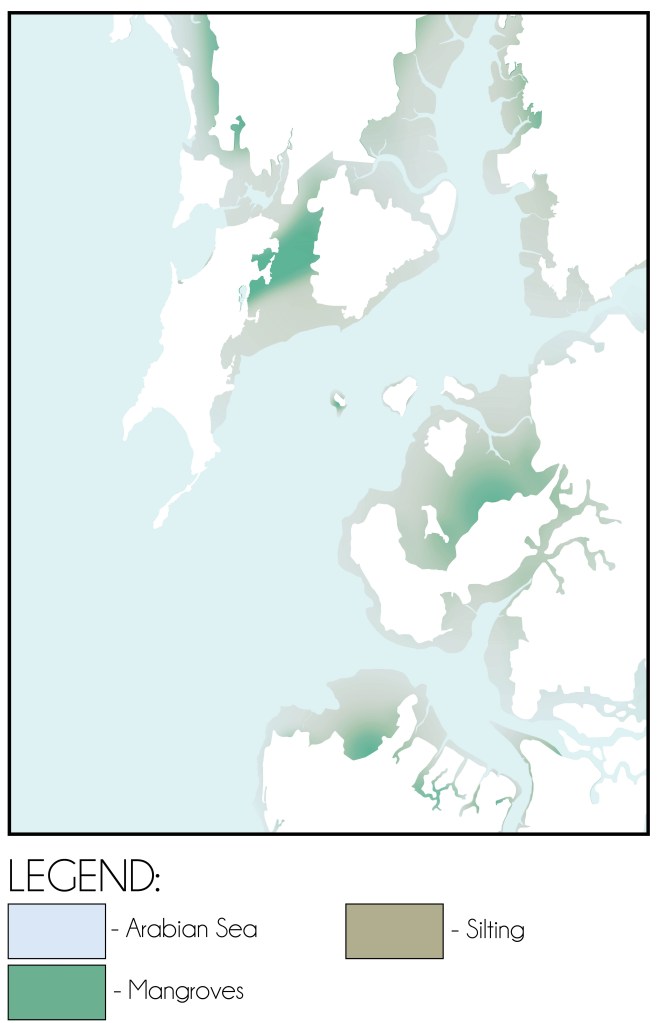
ONSET OF VEGETATIVE COLONISATION:
With the expansion of sediment-rich areas, natural colonisation by coastal vegetation, particularly mangroves, began to take hold.
However, since proximal and sea-front zones of mudflats and swamps increased the percentage of silt arrested by mangroves reduced which led to the formation of large stretches of mudflats with unchecked silt. During low tide this unchecked silt would flow with the ebb current and get deposited on the sea bed following the natural slope thereby catalysing the process of silting in the Mumbai Harbour.
MARITIME INFRASTRUCTURE AND TRADE:
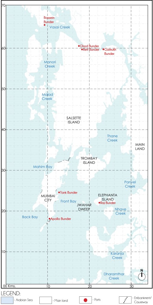
During this period, maritime activities continued through key port areas such as Padav Bunder and Tank Bunder on the island city, and Raj Bunder on Elephanta Island.
CONCLUSION:
The British consolidation of the Mumbai archipelago through the construction of embankments and causeways was undeniably a landmark engineering achievement, one that profoundly reshaped both the physical geography and the administrative organization of the region. By physically joining the seven islands into a contiguous landmass, the British facilitated urban expansion, enhanced mobility, and laid the foundation for Bombay’s emergence as a major colonial port city. However, this anthropogenic intervention came at a significant and often overlooked ecological cost. The disruption of the natural tidal network fundamentally altered sediment deposition patterns, replacing the dynamic equilibrium of tidal flows with stagnant or redirected water systems.
Bibliography:
- Input reduction and acceleration techniques in a morphodynamic modeling: A case study of Mumbai harbor; Author: Balaji Ramakrishnan, Niraj Pratap Singh, Satheeshkumar Jeyaraj
References:
- The Rise of Bombay: A Retrospect; Author: S. M. Edwardes Publisher: Times of India Press, Mumbai, 1902
- A Study on the Eastern Waterfront of Mumbai: A Situation Analysis conducted between August 2000 – December 2001; Author: Design Cell: Kamla Raheja Vidyanidhi Institute of Architecture and Urban Design Research Institute. Publisher: Urban Design Research Institute, Mumbai, 2001.
- Tides of Time: A History of Mumbai Port; Author: V. M. Kamath Publisher: Mumbai Port Trust, Mumbai.
Author’s Note:
If this topic interests you, explore the category titled the ‘The Dissolution of Mumbai Harbour‘ . The published articles under this category include:
- The Dissolution of Mumbai Harbour: An Introduction
- The Dissolution of Mumbai Harbour: A Conducive Setting
- The Dissolution of Mumbai Harbour: Influence of Anthropogenic Activities c. 1650-1668 A.D.
- The Dissolution of Mumbai Harbour: Influence of Anthropogenic Activities c.1668 to 1873 A.D.
- The Dissolution of Mumbai Harbour: Influence of Anthropogenic Activities c.1873 to 1914 A.D.
- The Dissolution of Mumbai Harbour: Influence of Anthropogenic Activities c. 1914 to 1947 A.D.

Leave a comment