The unpredictable monsoon literally wrecks havoc in the country without being biased to any region, state or climatic zones. In addition to the unpredictable rainfall, the magnitude of hardships encountered by the citizens residing in coastal areas, flood plains and close proximity to rivers multiply due to the river reaching danger mark on account of torrential rains, cloud bursts, release of water from upper catchment areas etc.
THE CURRENT FLOODING SCENARIO
India has experienced severe flooding in the year 2024. For instance, flooding of the R. Brahmaputra in Assam impacted 6,40,000 people across 19 districts and damaged approximately 1.08 lakh hectares of crop. The situation was worsened in Assam by flooding of the R. Barak and R. Kushiyara.
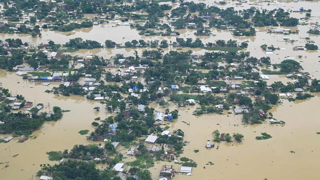
Source: https://www.thehindu.com/news/national/other-states/assam-flood-devastation-monsoon-brahmaputra-reason-cause/article65549836.ece
Another unfortunate incident was experienced in the state of Andhra Pradesh due to flooding in the R. Krishna and R. Budamera affecting approximately 2,70,000 people in Vijayawada alone.
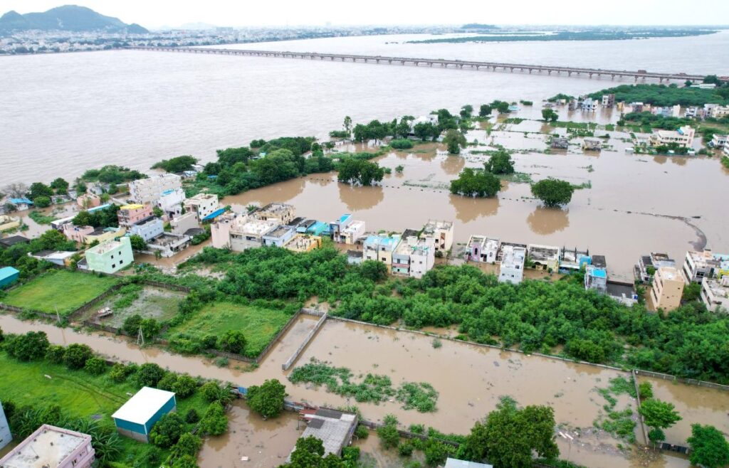
Source: https://www.therightnews.in/2024/09/06/floods-in-andhra-pradesh-damaged-crops-in-1-8-lakh-hectares-shivraj-singh-chouhan/
Other incidents of severe flooding in India can be traced to the states of Gujarat, Tripura, West Bengal, Uttarakhand, Himachal Pradesh, Bihar and Uttar Pradesh.
While the 21st Century urban issues are magnified due to the current climate crisis, a notable lesson on river management and sensitive planning can be adopted from the Mughal era.
THE GENIUS OF SITE SELECTION
The Mughal Empire came into existence during the Medieval Era. The Mughals reigned over many parts of South Asia from the present day Afghanistan in the North-West to the present day Bangladesh in the East and introduced different architectural typologies which were influenced by the Persian style of architecture. One such architectural typology was the ‘Bagh’. These ‘Bagh’ depicted the epitome of hydraulic engineering both at the macro-level and micro-level.
The prowess in hydraulic engineering at the macro-level can be witnessed by their selection of sites for the purpose of garden development. The Mughals strategically chose sites near rivers or waterbodies.
Source: The complete Taj Mahal by Ebba Koch
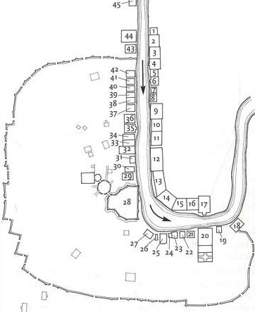
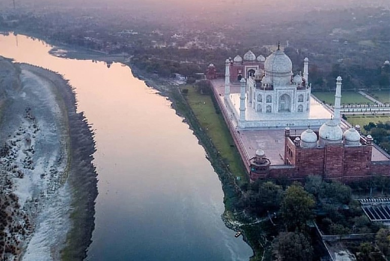
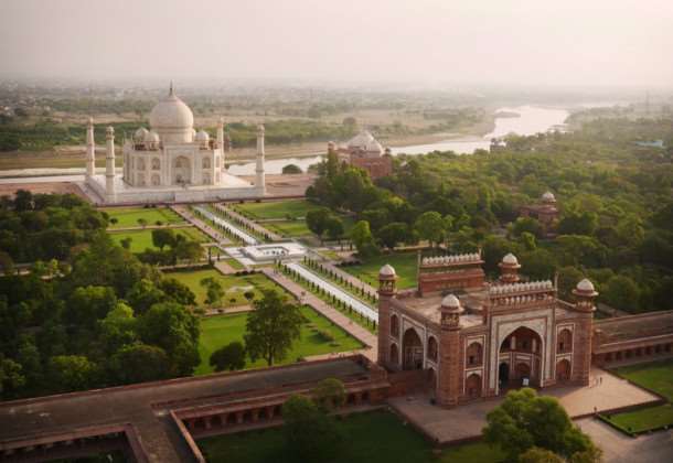
For instance as shown in Fig. 03, the Mughal city of Agra comprising of around 45 Gardens including some world renowned Gardens such as the Taj Mahal Gardens, the Mahtab Bagh (Bagh-i-Mahtab), Ram Bagh (Bagh-i-Nur Afshan), etc. were located on the banks of the river Yamuna. Likewise the Shalimar Bagh and Nishat Bagh in Kashmir were developed on the banks of the Dal Lake, the Mughal Garden at Pinjore was developed near the tributary of R. Ghagar, the Lotus Garden in Rajasthan was developed near the R. Chambal and the Brindavan Gardens in Karnataka was developed on the banks of the R. Kaveri.
The Mughals selected sites near River and Lakes to develop a Bagh or Garden since sustenance of a Bagh required large quantities of water year around. The location of a Bagh near a water source allowed these Bagh to benefit from the high groundwater levels generally observed in the flood plains of rivers or areas surrounding lakes thereby reducing the need to draw water from an external source and incase of unavailability of ground water during peak Summers the water could be drawn from the adjoining River/ Lake thereby ensuring year around supply of water for Horticultural activities.
A SYMBIOTIC RELATIONSHIP
While there is no seconding the fact that the ‘Bagh’ greatly benefitted from the genius of its location near a perennial water resource, on critical thinking it is evident that the water resource also greatly benefited from its close proximity to the Mughal Garden or ‘Bagh’ Infact the Bagh and the natural water resource be it pond, lake, stream or river shared a symbiotic relationship wherein the natural water resource provided water and the ‘Bagh’ provided protection to the natural water resource.
ASSIGNING A LAND-USE FOR NO MAN’S LAND:
Flood plains are defined as the area between the highest high flood line and the lowest low flood line that gets inundated during torrential rainfall. It is advisable to consider a minimum of 20 years record and a maximum of 100 years record to mitigate any risk to life. Assigned the status of flood plains, during the non-monsoon months or in the event of change in the course of a river, these river banks appear vacant and are susceptible to encroachment and development of slums.
However, from the plan of riverfront city of Agra indicated by Fig.03 it can be noted that during the Mughal Era, flood plains were treated differently. They were assigned a land-use. The flood plains in the river front city of Agra were used to develop approximately 45 gardens. The perception of flood plains therefore changes from a no man’s land available for encroachment and development of slums to an area with picturesque gardens thereby enhancing the valuation of flood plains while not compromising on its protection.
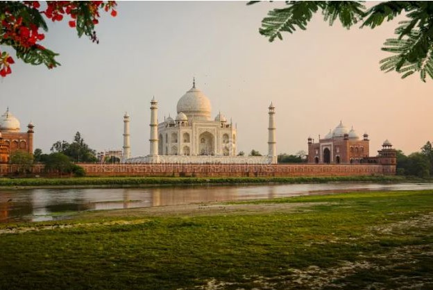
Source: https://www.shutterstock.com/image-photo/taj-mahal-mausoleum-agra-india
PROTECTION BY ENHANCED VALUATION
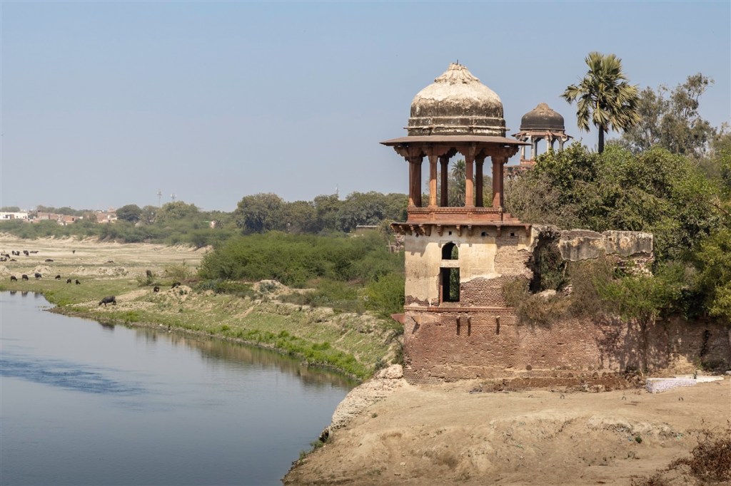
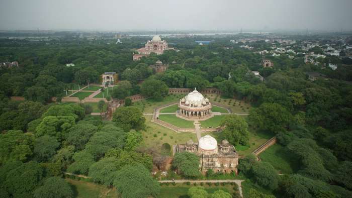
These Bagh’s often harboured breath taking monuments of historical and cultural significance. Harbouring of monuments in the Mughal Gardens or Baghs further raised the status of the natural water resources from a waterfront to a natural and beautiful backdrop for the monument. Protection of the river therefore became mandatory as an element enhancing the valuation of the monument.
Source: https://www.pelago.com
PROTECTION OF FLOOD PLAINS BY ADOPTING ECOLOGICALLY SENSITIVE LANDSCAPE PLANNING
Since, detailed landscape plans of all the Mughal Gardens are not available, the layout of the Taj Mahal Gardens provides some insight into the landscape planning practices followed during the Mughal era.
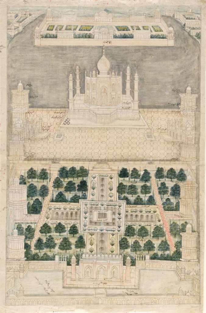
Contrary to the present scenario, the Taj Mahal Gardens were not vast stretches of lawn and hardscape areas.
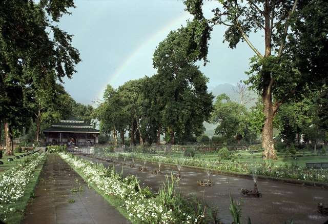
It is evident from the layout of the Taj Mahal Gardens that the Baghs were planned with about 5-10% of the area assigned to hardscape, about 15-20% area assigned to lawns and the remaining was comprised of wooded areas.
The presence of large wooded areas in most Mughal Gardens can be verified through their respective historical imagery.
Source: http://funnyphoto.eu
Source: https://www.google.co.in
Source: https://archnet.org
Source: https://commons.wikimedia.org
These wooded areas comprising of native trees were well equipped to sustain in inundated conditions during flooding of the natural water resource. Knowing the significance of wooded areas and forests, it can be concluded the roots of these trees planted in wooded areas could hold water thereby reducing the velocity of water and ensuring sufficient seepage to the ground thereby enhancing the ground water conditions. Therefore the inclusion of wooded areas provided ecological protection to the nearby natural water resource and its flood plain.
SIMILAR TRENDS, DISIMILAR RESULTS
The planning of a series of gardens along the flood plain of the R. Yamuna in the city of Agra did not ensure that the river would never flood, instead it ensured that in the event of a flood, the gardens would be the first line of defense capable of absorbing the environmental shock thereby preventing loss of life and property.
Similar trends of developing landscapes near natural water resources are on the rise and many examples can be cited such as the Sabarmati Riverfront, Pune Riverfront, Chambal Riverfront, Tapi riverfront etc. The rise in developing landscapes near riverfronts can be attributed to the issues of urban flooding and the need of urban river management. However the current landscapes lack ecological sensitivity towards the flood plain and are a mere act of bringing concrete right to the waters edge providing no relief from the raging rivers during heavy rains, cloud bursts or release of water from upper catchment areas.
CONCLUSION:
The conceptualization of developing riverfronts to mitigate flood risk and enhance the quality of water is a vital step towards managing urban rivers. The notification on the River Regulation Zone (RRZ) details out the considerations for delineating prohibited activities zone, restricted activities zone and regulated activities zones along the flood plains of a river. Also, the River Regulation Zone (RRZ) notification clearly specifies the permissible and non-permissible activities in the various prohibited, restricted and regulated zones of the flood plain.
However, though the RRZ notification allows for landscape development, it fails to define guidelines for landscape development in terms of:
- Percentage of permeable and non-permeable surfaces allowed in the flood plains to ensure maximum water seepage.
- Percentage of lawn area allowed while developing landscapes along natural water resources and its flood plains.
- Percentage of wooded areas to be obligatory for riverfront development.
In the absence of stringent guidelines for landscape development along natural water resources and its flood plains, the core intent of managing rivers and natural water resources is incomplete. Important landscape planning guidelines can be derived from the Mughal Baghs that have shared a symbiotic relationship with the natural water resources over a considerable extent of time.

Leave a comment