The Dissolution of Mumbai Harbour: An Introduction concludes by enlisting the factors responsible for the rise of port activities in the Mumbai Harbour and include:
- Strategic location of the Mumbai Harbour along the Western Coastline of India
- The physiography of Mumbai Harbour
- The oceanography of Mumbai Harbour
- The tidal exchange between the Front Bay and Back Bay
- The resultant geomorphological processes peculiar to the region
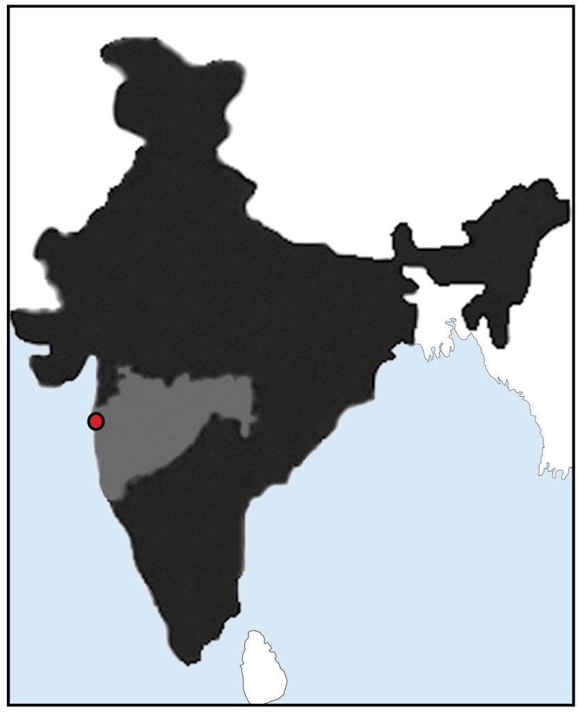
STRATEGIC LOCATION OF THE MUMBAI HARBOUR ALONG THE WESTERN COASTLINE OF INDIA
Source: Author
The archipelago of Mumbai was strategically located along the Western coast of the Indian peninsula as shown in Fig.01. The Western Coast of India is submergent in nature due to subsidence along one of the fault lines. This submergent nature of the Western Indian coastline facilitated the formation of a natural Harbour in the Front Bay.
Port activities in Mumbai were developed by the British during the era of British dominance over the world.
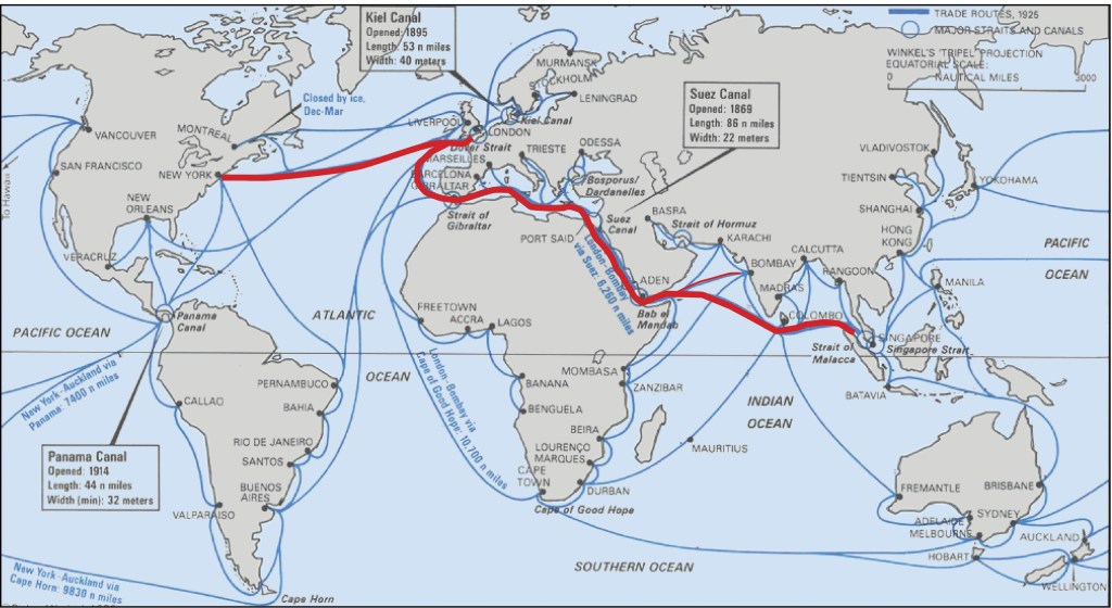
Mumbai – Manchester of the East was located along the most important world sea-trade routes such as New York-London-Singapore as highlighted in Fig.02. The opening of the Suez Canal in 1869 made Mumbai the closest Indian Port to Europe thereby enhancing its prospects and propelling its status to a central position – ‘The Gateway to India.’ By the last quarter of the 19th century Mumbai’s dominance on the urban scene in Western India was firmly established.
Source: https://www.researchgate.net/figure/The-main-sea-routes-between-the-continents-2004-Rodrigue-2004_fig14_311981730
THE PHYSIOGRAPHY OF MUMBAI HARBOUR
Physiography refers to the physical features of the Mumbai Harbour and can be holistically understood through analysis of the landmass encompassing the Mumbai Harbour, coastline characteristics and bathymetry.
LANDMASS ENCOMPASSING THE MUMBAI HARBOUR
Source: Author
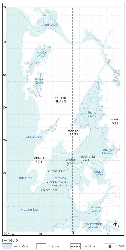
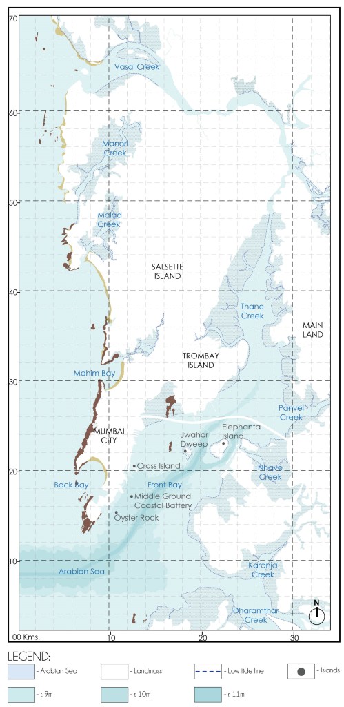
The Mumbai Harbour is surrounded by land on three sides forming a Bay. As shown in Fig. 03, to the West of the Harbour lies the island city of Mumbai, towards the North-West lies the Mumbai Suburban Region whereas towards the East lies the main land.
In addition to the landmass encompassing the Mumbai Harbour, the islands lying within the Harbour also influence the physiographic characteristics of the Mumbai Harbour. Southern most of these islands is the Oyster Rock comprising of a small group of rocky outcrops. Northwards from the Oyster Rock are the Middle Ground Coastal Battery Island and Cross Island. Towards the North-East of the Cross Island lie the islands of Jwahar Dweep and Elephanta.
CHARACTERISTIC FEATURES OF THE COASTLINE
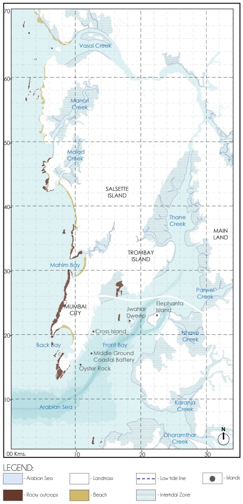
The present day coastline along Mumbai Harbour is defined by causeways and sea walls built by demolishing the natural character. Beyond the sea walls traces of the natural physiographic character can be observed as indicated in Fig. 04.
The natural physiographic character of the Mumbai Harbour is defined by Rocky outcrops and intertidal zones dominated by mudflats, swamps and mangroves.
Traces of rocky outcrops are observed in the Mumbai Harbour at Colaba Tip and near Trombay.
Intertidal zones characterized by mudflats, swamps and mangroves are observed near Trombay Island, along the Thane Creek, Panvel Creek, Nhava Creek, Karanja Creek and Dharamthar Creek. These coastline characteristics are a result of the region’s oceanography.
BATHYMETRY
Source: Author
Bathymetry refers to the depth of water in Oceans, Seas, Rivers.
Bathymetry helps determine the available draught depth of the main navigation channel and is amongst the most important factors defining the possibility of shipping, maritime transportation and development of Ports in a Harbour. Greater draught depths allows for larger vessels with better carrying capacity to dock in the Harbour.
Fig. 05 indicates bathymetry of the Mumbai Harbour. The continental shelf of the Mumbai Harbour Region gradually slopes from the coastline towards the center. The Harbour is the deepest in the center till the Jwahar Dweep and Elephanta islands. The main navigation channel of Ports in the Mumbai Harbour coincides with the areas that have maximum water depth.
The central location of the main navigation channel allows for ease of accessibility to the Mumbai Port located along the Eastern Waterfront of the island City, Pir Pau located at the Southern tip of Trombay, Jwahar Dweep and Nhava Sheva Port located on the Western Coast of Navi Mumbai.
THE OCEANOGRAPHY OF MUMBAI HARBOUR
Oceanography of the Mumbai Harbour is defined by a complex interaction between the physiography and various conditions, such as tides, currents, waves, river discharges, etc.
TIDES
Tides are very long-period waves that move through the ocean in response to the forces exerted by the moon and the sun. Tides originate in the ocean and progress toward the coastlines where they appear as the regular rise and fall of the sea surface. Tides are an important factor to be considered for port activities as they facilitate navigation by helping ships to arrive at the dock easily.
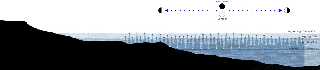
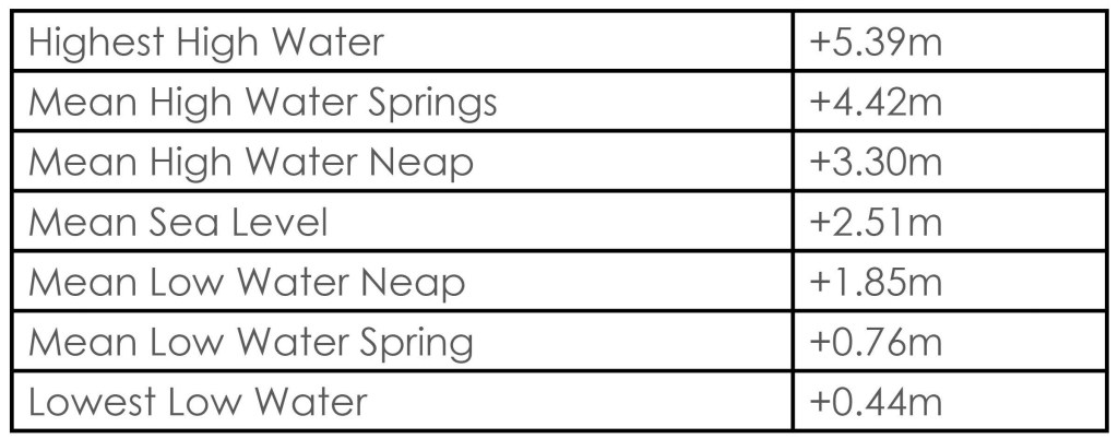
The coastline of Mumbai is dominated by semi-diurnal tides i.e., occurrence of two high tides & two low tides everyday. Fig. 06 indicates the tidal data for one lunar cycle.
Source: Graphics by Author based on the tidal data from
https://www.tideschart.com/India/Maharashtra/Mumbai
Fig. 07 enlists the tidal range observed in the Mumbai Harbour. It is noteworthy that a tidal range of 4.7m during spring tide and 1.7m during neap tide is observed at Apollo Bunder. Higher tidal range up to 5.2m during spring and 2.3m during neap tide is observed near Trombay, which is located to the
Source: https://www.mumbaiport.gov.in
north of Mumbai Port. This increase in the tidal range is attributed to the funnel-like shape of the Mumbai Harbour towards the upstream. [1]
TIDAL CURRENTS
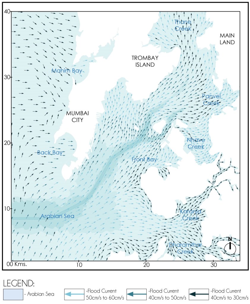
Tidal currents are created by tides and are an important factor to be considered for navigation as they help ships to speed up and slow down. Currents are of two types namely Flood Current and Ebb Current. Flood currents are characterized by tidal rise and water moving towards the shore thereby helping ships reach a dock. Ebb currents are characterized by receding tides and water moving away from the shore thereby helping ships sail towards the open sea.
Source: Graphics by Author based on data from Numerical Model Study of Hydrodynamics, Siltation and Wave Tranquility Study for the Navigation of the Dharamtar Creek (Amba River). published by Ministry of water resources, Central Water and power research station, Pune.
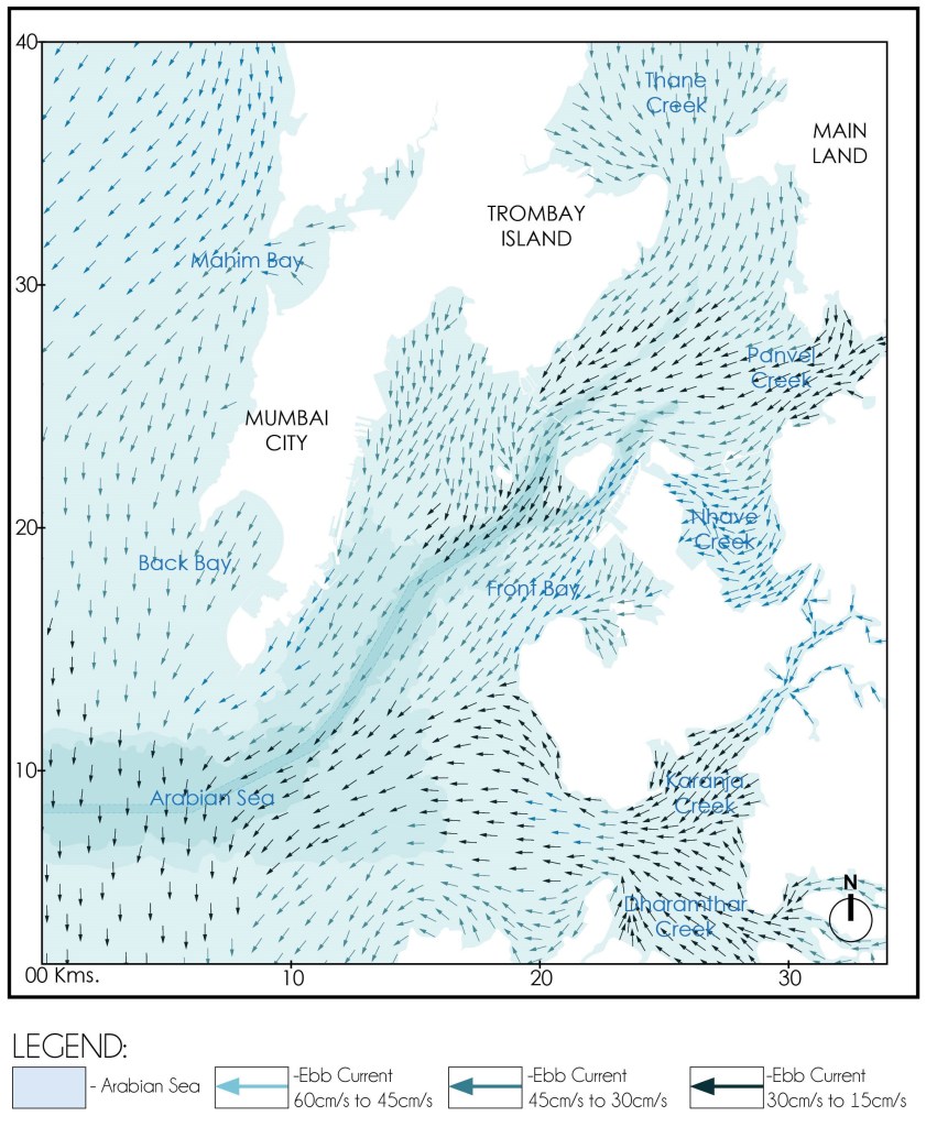
Source: Graphics by Author based on data from Numerical Model Study of Hydrodynamics, Siltation and Wave Tranquility Study for the Navigation of the Dharamtar Creek (Amba River). published by Ministry of water resources, Central Water and power research station, Pune.
The currents in the harbour are essentially caused by the tides and are not influenced to any extent by monsoons.[1] The currents observed in the Mumbai Harbour are unsteady and translatory type i.e. they change from flood to ebb in one and a half hours. The magnitude and direction of currents varies depending upon the location, time, depth, physiographic form of the Mumbai Harbour and presence of islands within the Harbour.
As indicated in Fig. 08 the predominant direction of tidal currents in the Harbour is towards the North-East during the flood. The maximum flood current speeds in the main navigation channel reaches up to 50cm/s during spring tide and 45cm/s during neap tide.
As indicated in Fig. 09 the predominant direction of tidal currents in the Harbour is towards the South-West during the ebb. The maximum ebb current speeds in the main navigation channel reaches up to 60cm/s during spring tide and 40cm/s during neap tide.
Maximum residual currents up to 40cm/s are observed near Colaba tip. [1]
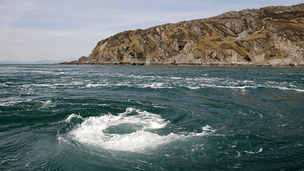
EDDIES
An eddy is loop a circular or a small spinning current formed around an obstruction like a rock and is cut off from the main current. They are comparatively small, short-lived circulation patterns in the ocean. Occasional anti-cyclonic eddies are observed in the vicinity of Elephanta and Butcher Island.
WAVES
The significant waves entering the harbour are the long period swell waves generated by deep sea storms. These mainly arise just before and during the monsoon and their direction of approach is normally from South-West. Whatever the wave front orientation outside the harbour, the waves running upto the harbour tend to be refracted in to a constant pattern. Waves are also substantially attenuated by the time they reach the berthing facilities in the harbour.
As the Mumbai harbour is sheltered, no significant wave climate exists in the harbour area. The wave height reaches a maximum of 1.5m under normal conditions with wave period ranging from 6s to 10s.
DISCHARGES FROM RIVERS AND CREEKS
The Mumbai Harbour lies in the Southern portion of Ulhas River estuary and opens into Panvel Creek, Nhava Creek, Karanja Creek and Dharamthar Creek. R. Amba, R. Patalganga and R. Gadhi empty into the Mumbai Harbour. The discharges from these rivers and creeks deposited into the Mumbai Harbour play an important role in defining the oceanography of the Harbour.
TIDAL EXCHANGE BETWEEN THE FRONT AND BACK BAY
At present there is no tidal exchange between the Front Bay and Back Bay due to construction of causeways connecting the separate islands to form the island city of Mumbai we know today. This anthropogenic activity has greatly impacted the oceanography of Mumbai Harbour.
THE RESULTANT GEOMORPHOLOGICAL PROCESSES PECULIAR TO THE REGION
Geomorphological processes refers to the physical or chemical processes that alter the Earth’s surface.
In the case of the Mumbai Harbour, geomorphological processes peculiar to the region refers to the processes that are altering the configuration of the coastline defining the Mumbai Harbour and bringing about changes in the sea bed. These include the weathering of the rocky outcrops by lashing waves, deposition of silt by tidal currents and river discharges leading to the formation mud flats and action of natural colonization to form mangroves.
These geomorphological processes have a direct impact on navigation as they may catalyze or inhibit the deposition of silt thereby determining the depth of water available for shipping activities.
INFLUENCE OF ANTHROPOGENIC ACTIVITIES
The factors defining the oceanography and geomorphological processes of the Mumbai are affected and catalyzed by anthropogenic activities and are gradually changing over time.
In order to understand the changing oceanography and geomorphological processes at work in the Mumbai Harbour catalyzing silting, the major anthropogenic activities that have altered the coastline of the island city have been considered from the first known records of inhabitation on the archipelago to the present day. and indicated in Fig.11. The major anthropogenic activities that altered the coastline of Mumbai can be divided into 6 cases and include:
- CASE I: c. 1650-1668 A.D. : An archipelago of 7 Islands
- CASE II: c. 1668-1873 A.D.: Construction of Causeways
- CASE III: c. 1873-1914 A.D.: Construction of Ports
- CASE IV: c.1914-1947 A.D.: Expansion of Ports-Phase I
- CASE V: c.1947-2000 A.D.: Expansion of Ports-Phase II
- CASE VI: Post 2000 A.D.: Construction of Offshore Container Terminal and Mumbai Trans Harbour Sea Link
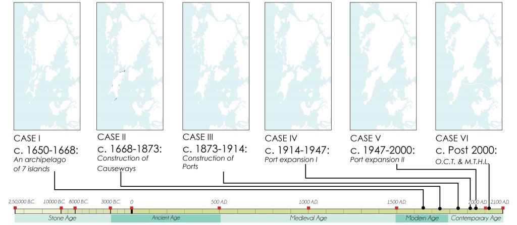
Source: Graphics by Author
Bibliography:
- Input reduction and acceleration techniques in a morphodynamic modeling: A case study of Mumbai harbor; Author: Balaji Ramakrishnan, Niraj Pratap Singh, Satheeshkumar Jeyaraj
References:
- The Rise of Bombay: A Retrospect; Author: S. M. Edwardes Publisher: Times of India Press, Mumbai, 1902
- A Study on the Eastern Waterfront of Mumbai: A Situation Analysis conducted between August 2000 – December 2001; Author: Design Cell: Kamla Raheja Vidyanidhi Institute of Architecture and Urban Design Research Institute. Publisher: Urban Design Research Institute, Mumbai, 2001.
- Tides of Time: A History of Mumbai Port; Author: V. M. Kamath Publisher: Mumbai Port Trust, Mumbai.
Author’s Note:
If this topic interests you, explore the category titled the ‘The Dissolution of Mumbai Harbour‘ . The published articles under this category include:
- The Dissolution of Mumbai Harbour: An Introduction
- The Dissolution of Mumbai Harbour: A Conducive Setting
- The Dissolution of Mumbai Harbour: Influence of Anthropogenic Activities c. 1650-1668 A.D.
- The Dissolution of Mumbai Harbour: Influence of Anthropogenic Activities c.1668 to 1873 A.D.
- The Dissolution of Mumbai Harbour: Influence of Anthropogenic Activities c.1873 to 1914 A.D.
- The Dissolution of Mumbai Harbour: Influence of Anthropogenic Activities c. 1914 to 1947 A.D.

Leave a comment